[6] Validation of GOSAT Data Products
In order for the GOSAT data products to be utilized meaningfully in the science community, uncertainties associated with the data products need to be clarified through validation. High-precision data obtained independently by ground-based instruments and aircrafts are used to validate the data products. Improvements in the data processing algorithms are made based on the validation results.
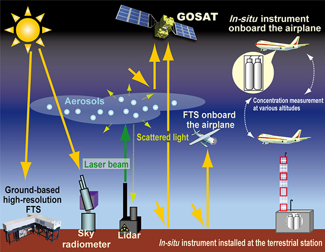
Validation of the GOSAT data products acquired through the routine processing of the GOSAT observational data (Figure 7) is necessary in order for the data products to be used meaningfully in the science community. The precision and bias of the data products must be clarified. To this end, the GOSAT data validation team has been utilizing high-precision reference data obtained through ground-based and airborne measurements (Figure 24). For validating the Level 2 column abundances of CO2 and CH4, the team uses data from ground-based high-resolution Fourier transform spectrometers and in-situ observation instruments installed on aircrafts. Properties of clouds and aerosols calculated in the routine data processing are checked against the data obtained with remote sensing instruments such as ground-based sky radiometers and lidars. The estimated source/sink strengths and three-dimensional distributions of CO2 and CH4 are evaluated by comparing with other model outputs.
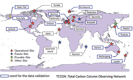
The data validation team has carried out a series of initial data validation activities and compared the Level 2 data products to the ground-based and airborne reference data. Figure 25 shows the sounding locations of the ground-based high-resolution Fourier transform spectrometers in the Total Carbon Column Observing Network and and other independent sites (https://tccon-wiki.caltech.edu/). Data obtained in Japan, Europe, Oceania, and North America have been used in these validation activities. Also, data collected by the aircrafts of Japan Airlines that participate in CONTRAIL (Comprehensive Observation Network for Trace gases by Airliner) project and the US National Oceanic and Atmospheric Administration's airborne measurement program have been employed. The results of the comparison (as of May 2014) indicated that the retrieved Level 2 CO2 and CH4 column abundances were lower than the reference values. The latitudinal pattern of the Level 2 zonal means, however, were broadly consistent with those of the reference values. The data product validation activity will continue in the days to come, and the results acquired will be reflected in the improvement of the data processing algorithms.