![GOSAT PROJECT [ THE GREENHOUSE GASES OBSERVING SATELLITE: GOSAT 'IBUKI' ]](../img/img_top.jpg)
- Top
- > Technical Information
- > News & Updates
News & Updates
Update on the GOSAT Data Policy
Japan Aerospace Exploration Agency (JAXA), National Institute for Environmental Studies (NIES), and Ministry of the Environment of Japan (MOE) agreed to revise the definition of the GOSAT data products in March 2015 and updated the GOSAT Data Policy. Each GOSAT data user is expected to read and follow this GOSAT data Policy revision B hereafter.
Major revised items are listed in the below;
*The list of GOSAT data products was updated. (Table 1)
*Definition of Calibration/Validation Stages for Level 1 and 2 of standard products (version up stage) was added. (Table 2-2, 3-2)
*Definition of Evaluation stages for Level 3 and 4 of standard products were added. (Table 4 and 5)
*GOSAT data user categories were consolidated, and definition of available users for data each stage and level of GOSAT standard products was clarified. (Table 6 to 10)
*Provision for the commercial use of the GOSAT data products was deleted.
*Indication in any publication for the GOSAT data use was changed.
*Permission for free redistribution of the GOSAT standard data products was added.
(Currently it links to Japanese version. English version will be available in April, 2015.)
The explanation of the "GOSAT Path Calendar" is here.
GOSAT Path Calendar 2015 was publised.
ENVI (Updated GOSAT Importer)
We have changed the way to provide the ENVI extension file to read some of CAI products (CAI L1B, CAI L1B+, CAI L2 Cloud Flag and CAI L3 NDVI). If you want to get it, please send an e-mail to  . Please also remind it is applicable only for ENVI Classic mode.
[How to setup]
- Please decompress the "read_gosat.sav" file (zip file: 76KB) which is attached to the reply mail from .
- Please un-compress the downloaded file and save "read_gosat.sav" in "save_add" directory in "ENVI" directory. If "read_gosat.sav" was already stored in the directory, please overwrite it after saving it for your own back-up.
- [ENVI 4.8]
- Windows : C:/Program Files/ITT/IDL/IDL80/products/envi48
- Linux : /usr/local/itt/idl/idl80/products/envi
- Macintosh : /Applications/itt/idl/idl80/products/envi
- [ENVI 5.0]
- Windows : C:/Program Files/Exelis/ENVI50/classic/
- Linux : /usr/local/exelis/envi50/classic
- Macintosh : /applications/exelis/envi50/classic
- [ENVI 5.1]
- Windows : C:/Program Files/Exelis/ENVI51/classic/
- Linux : /usr/local/exelis/envi51/classic
- Macintosh : /applications/exelis/envi51/classic
- Please store "usradd.txt" file in "menu" directory after saving "useradd.txt" in "menu" directory in "ENVI" directory for your own backup.
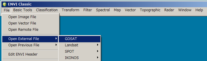
- Please restart ENVI with "Classic Mode" and you will see "GOSAT" in the pull down menu to select "File" -> "Open External File" for reading CAI products of HDF.
[Disclaimer]
Please assume that NIES is not responsible for any direct or indirect damage, loss, and other prejudice in relation to or caused by use of this tool.
You can read GOSAT data with new MultiSpec!
Now, you can read GOSAT products* with new MultiSpec, which is a free image processing software updated by Purdue University.
(Provider of the service: Purdue University)
- CAI L1B
- CAI L1B+
- CAI L2 Cloud flag
- CAI L3 Global Radiance
- CAI L3 Global Reflectance
- CAI L3 NDVI Both Macintosh and Windows versions are downloadable.
[Disclaimer]
Please assume that NIES is not responsible for any direct or indirect damage, loss, and other prejudice in relation to or caused by use of this tool.
GOSAT Standard Mesh Point (SMP)
The information on GOSAT Standard Mesh Point (SMP) is published.
SMP is downloadable from following link.
- Mesh Pattern: 1, 3, 5(new), 7, 9
- GOSAT SMP (zip file: 4.25MB)
- 2014/9/11 04:10 (UT) - : Pattern 1
- 2014/5/30 23:00 - 2014/9/11 04:10 (UT) : Pattern 1 or 3
- 2010/8/1 - 2014/5/30 23:00 (UT) : Pattern 3
- 2009/6/26 3:00 (UT) - 2010/8/1 : Pattern 5(new)
- Mesh Pattern: 5 (old)
- Old 5 points observation pattarn of GOSAT SMP (zip file: 584KB)
- 2009/4/23 - 2009/6/26 3:00 (UT) : Pattern 5(old)
http://www.adobe.com/products/acrobat/readstep2.html