[2] GOSAT Instruments and Observational Methods
GOSAT observes infrared light reflected and emitted from the earth's surface and the atmosphere. Column abundances of CO2 and CH4 are calculated from the observational data. The column abundance of a gas species is expressed as the number of the gas molecules in a column above a unit surface area.
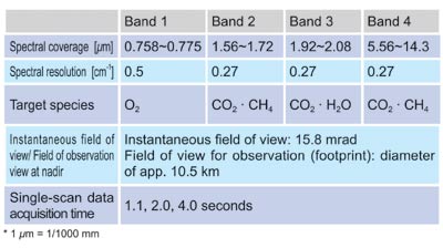
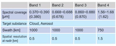
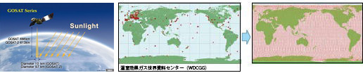
GOSAT flies at an altitude of approximately 666 km and completes one revolution in about 100 minutes. The satellite returns to the same point in space in three days (Figure 6). The observation instrument onboard the satellite is the Thermal And Near-infrared Sensor for carbon Observation (TANSO). TANSO is composed of two subunits: the Fourier Transform Spectrometer (FTS) and the Cloud and Aerosol Imager (CAI). Tables 1 and 2 summarize the target gas species, spectral coverage, and other specifications of these two instruments.
FTS is an instrument that utilizes optical interference. Within the instrument the incoming light is split into two beams which propagate in separate optical paths to create an optical path difference between the two. These beams are then recombined to cause interference. FTS measures the intensity of the interference by continuously changing the optical path length difference. A spectrum, which is distribution of light intensity over a span of wavelength, is obtained via performing mathematical operation called the Fourier transform on that measured data.
FTS observes sunlight reflected from the earth's surface and light emitted from the atmosphere and the surface. The former is observed in the spectral bands 1 through 3 of FTS in the daytime, and the latter is captured in band 4 during both the day and the night. Prior to reaching the detectors of the instrument, the light in the bands 1 through 3 is split into two orthogonally-polarized components (P and S components) and measured independently. The light in the band 4, however, is not split. The instrument thereby observes the incoming light in seven different channels. The reflection character of sunlight over land and that of over water differ significantly. Observation of reflected light over the surfaces of oceans and lakes is difficult since the water absorbs sunlight. The water, however, reflects sunlight specularly in certain directions. The instrument thus targets such points when observing over large water surfaces.
CAI visualizes the state of the atmosphere and the ground surface during the daytime. The image data from CAI are used to determine the cloud existence over an extended area that includes the FTS's field of view (FOV). When clouds and aerosols are detected in FOV, cloud characteristics and aerosol amounts are calculated. The information is used to correct the effects of the clouds and the aerosols on the spectra obtained with FTS.
Over the three-day period, FTS takes fifty-six thousand measurements, covering the entire globe. Since the analysis is limited to areas under clear sky conditions, only two to five percent of the data collected are usable for calculating column abundances of CO2 and CH4. Nevertheless, the number of data points significantly surpasses the current number of ground monitoring stations, which is below 200. GOSAT serves to fill out the blanks in the ground observation network.