![GOSAT PROJECT [ THE GREENHOUSE GASES OBSERVING SATELLITE: GOSAT 'IBUKI' ]](../../img/img_top.jpg)
2011
April, 2011
April 20, 2011
On March 11, 2011, a 9.0-magnitude earthquake hit north eastern Japan (the Great East Japan Earthquake). The "IBUKI" satellite continued its nominal observation as there was no interruption to the control of the satellite, however, the NIES GOSAT Project office was closed for the following week due to the power failure. On March 22, as the office was reopened, we started to work on the recovery of the GOSAT Data Handling Facility. On April 1, we were able to restart data-processing and the data distribution service.
These images show the inundated areas. The images were generated from the data acquired by the Cloud and Aerosol Imager on “IBUKI.” The difference between the data from April 1, 2011 acquired three weeks after the earthquake (center), and the data acquired about one year prior to the earthquake (left) is that the areas submerged in water after the earthquake had lower reflectance ratios. These areas are marked in red (right). April 1, it was two days before the spring tide, and the tide was full at "IBUKI"'s observation. The inundated areas are visible along the coastline from Miyagi Prefecture to Fukushima Prefecture. If you check these areas on a map, the inundated areas correspond with the location of former river mouths and reclaimed lands. In the inundated area, tsunami destroyed tide embannkments besides the ground subsided. Cloud shadows also appear in red in some parts of the image.
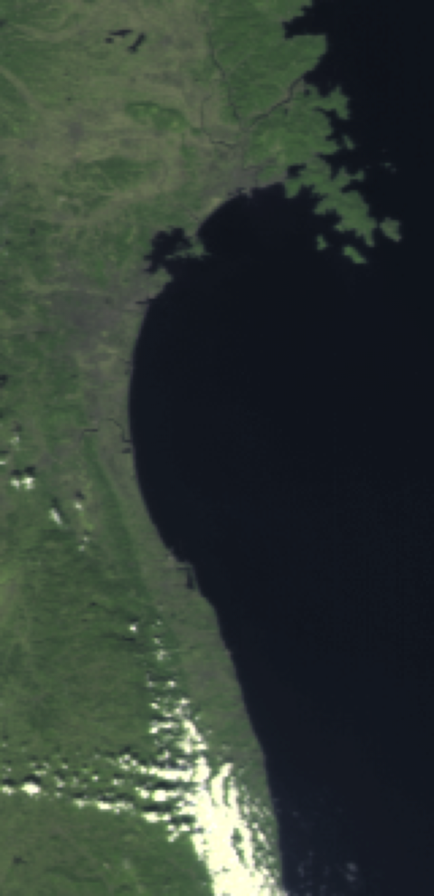
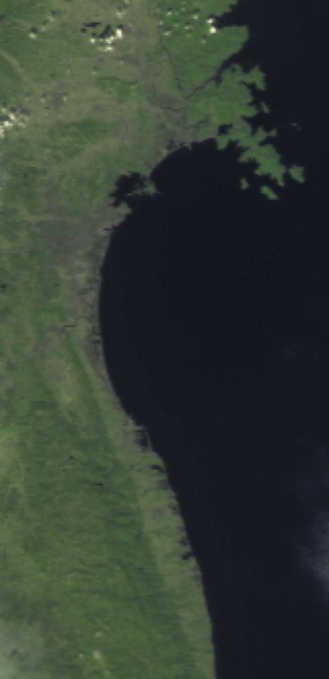
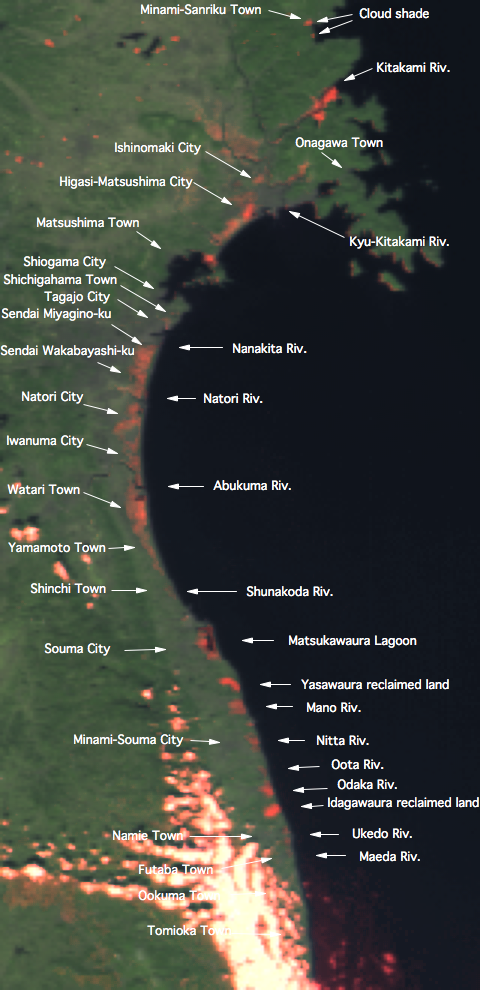
(Left) Tohoku area in Japan on March 19, 2010, one year prior to the earthquake observed by "IBUKI." (Center) Tohoku area in Japan on April 1, 2011, three weeks after the earthquake observed by "IBUKI." (Right) The areas submerged in water after the earthquake that had lower reflectance ratios are marked in red. Cloud shadows also appear in red in some parts of the image. (Click on images to enlarge.)
April 5, 2011
We, the NIES GOSAT Project team, sincerely express our deepest sympathy and condolence to the people affected by and suffering from the Tohoku Kanto Earthquake. The huge earthquake hit also damaged our system and GDAS had to be stopped for a while. We apologize to all the GDAS users for inconveniences that the stop of GDAS might have caused.
GDAS (http://data.gosat.nies.go.jp) was partially recovered and re-started on April 1, 2011. You are accessible to the products which had already been processed by the time of the earthquake and were confirmed as OK by brief system check. However, in fact, the GOSAT system is yet unable to fully process newly acquired data for reason of preparation status of still-unrecovered associated systems. The unprocessed data at the time of the earthquake hit still remain unprocessed at this moment, and it is estimated to take some little time to get all the processing ready.
You might find problems in performance of GDAS and find products unsatisfactory. For any problems and inquiries, please send your message to the GOSAT Support (![]() ). Your understanding of the current situation and your assistance would be greatly appreciated.
). Your understanding of the current situation and your assistance would be greatly appreciated.
1.Release of the processed data products
You can search, order and download the products which had already been processed by the time of the earthquake.
*FTS SWIR L2, CAI L1B, CAI L1B+, and CAI L2 cloud flag: from April 1, 2011
*FTS L1B, FTS SWIR L3, and CAI L3: from April 5, 2011
2.Observation request
We have started accepting observation requests of GOSAT/FTS (for the period between June 6 and July 3, 2011) from the GOSAT RA Principal Investigators (PIs).
3.Product Download
The ordered products will be automatically deleted after 7 days from the order. If you were unable to get the ordered products due to the stop of GDAS, please order the products again. We apologize for this trouble.
April 5,2011
NIES GOSAT Project Office